 Shakesphere
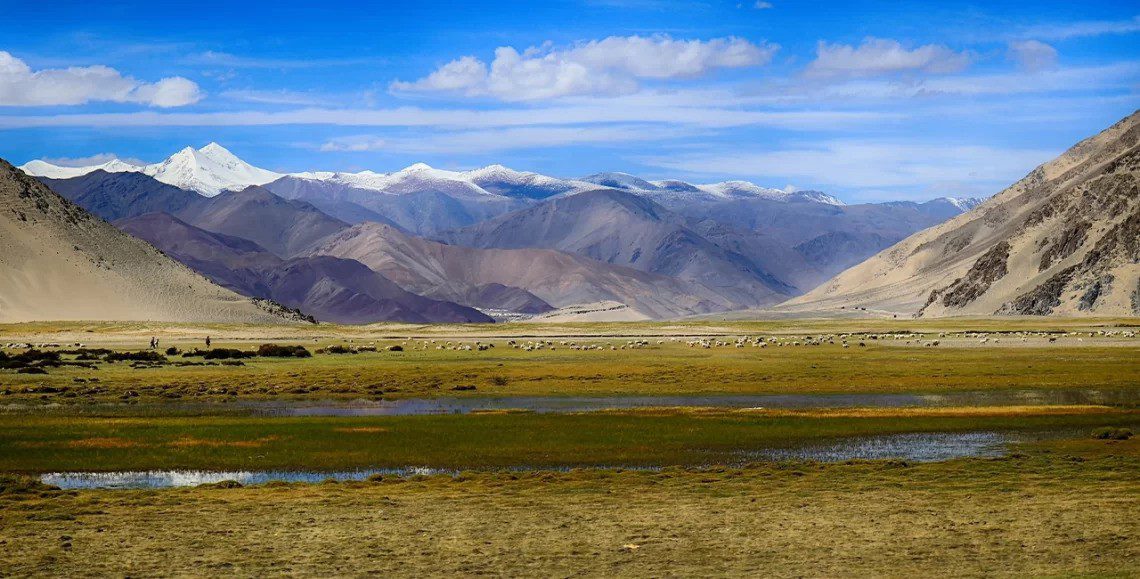
Ladakh looks bare from a distance. There are no forests to hide the slopes, little soil to soften the ridgelines, and almost nowhere for the structure of the mountains to disappear. That apparent emptiness is one reason the geology of Ladakh is so extraordinary: the land reads almost like an exposed archive of plate tectonics.
Granite that crystallised from ancient magma, fragments of oceanic crust, deep-sea sediments, high-pressure metamorphic rocks, geothermal minerals and active tectonic boundaries all occur within a region that can be crossed by road in days. To a traveller the colours may first appear as scenery. To a geologist they are evidence of vanished oceans, volcanic arcs, subduction and the collision of India with Eurasia.
This essay is not a catalogue of supposed mineral riches, and it does not treat every metallic-looking stone as an ore deposit. The more interesting story is larger: why Ladakh contains such different rocks in such close proximity, what minerals are actually documented, and how those rocks record the building of the Himalaya.
Geology of Ladakh: the short version
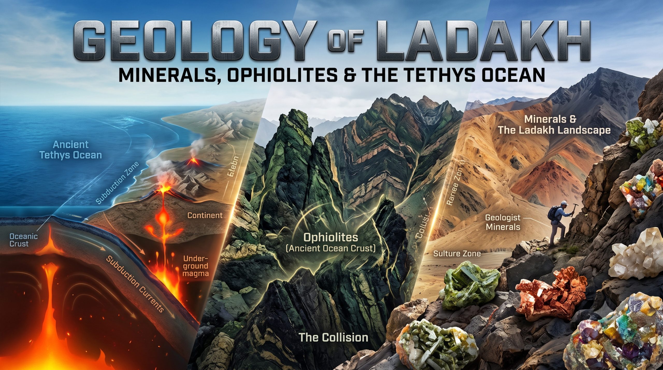
Ladakh sits across one of the most important tectonic regions on Earth. From south to north, the landscape brings together parts of the Indian continental margin, the Indus Suture Zone, the Ladakh magmatic arc and batholith, the Shyok Suture Zone, and rocks associated with the Karakoram block. These belts are not random. They are pieces of a long geological sequence assembled as the Neo-Tethys Ocean closed and the Indian Plate converged with Eurasia.
Research by the Wadia Institute of Himalayan Geology and India’s Department of Science and Technology describes the Ladakh Magmatic Arc as a record extending across roughly 130 million years of subduction, magmatism and continental collision. Rocks of the Dras–Nidar arc, the Ladakh Batholith and younger post-collisional intrusions preserve different stages of that history.
If there is one idea to keep while travelling through Ladakh, it is this: the mountains are not a single block of “Himalayan rock.” They are an assembled landscape.

Before the Himalaya: the Neo-Tethys Ocean
Long before the present mountain ranges existed, an ocean separated the Indian Plate from Eurasia. Geologists call it the Neo-Tethys. Oceanic crust formed, sediments accumulated on the sea floor, volcanic arcs developed above subduction zones, and fragments of these environments were later caught inside the collision zone.
As the oceanic plate descended beneath the Eurasian margin, melting generated magma. Over millions of years this produced volcanic and intrusive bodies that became part of the Trans-Himalayan arc. The modern Ladakh landscape therefore contains both material derived from ancient oceanic settings and large bodies of igneous rock formed above a subduction system.
This is why the phrase “Ladakh was once under the sea” is useful only as a beginning. The more accurate story is richer: different parts of today’s Ladakh preserve different pieces of an ocean, its margins, its volcanic arcs and the collision that finally closed it.
The Ladakh Batholith: a mountain range born from magma
One of the dominant geological bodies of the region is the Ladakh Batholith, part of the wider Kohistan–Ladakh magmatic system. A batholith is an enormous body of intrusive igneous rock formed when magma cools and crystallises below the surface. Later uplift and erosion expose that once-buried rock.
Much of the Ladakh Batholith is granitoid rock—commonly described in research as granite to granodioritic compositions. Quartz and feldspar are major constituents, with minerals such as biotite and other accessory phases recording the chemistry and cooling history of the magma.
For a traveller this matters because the pale, massive rock around the Indus Valley is not simply a neutral backdrop. It is part of a fossil magmatic system created above an oceanic plate that was being consumed beneath Asia.

The suture zones: where vanished oceans survive in stone
A geological “suture” is the scar left where major crustal blocks or continents joined after an ocean closed. Ladakh contains two globally important examples: the Indus Suture Zone to the south of the Ladakh Batholith and the Shyok Suture Zone farther north.
These zones contain complex mixtures of rock. Ophiolites are especially important. An ophiolite is a fragment of oceanic lithosphere that has been preserved on land rather than disappearing completely into a subduction zone. In Ladakh, researchers have studied ophiolitic rocks and mélanges at places including Nidar, Zildat and Shergol.
The rock associations can include ultramafic rocks, gabbros, basalts, radiolarian cherts and altered mantle rocks. Chromite-bearing ultramafic rocks have also been documented in the region. These occurrences are scientifically important because they preserve information about the mantle and the ocean floor that existed before the continental collision.
For readers who want a more mineral-focused companion to this geological overview, see our essay Stones That Remember: A Mineral Journey Through Ladakh.
Tso Moriri and the rock that went deeper than most mountains are high
Some of Ladakh’s most remarkable rocks come from the Tso Morari crystalline complex. Researchers have identified coesite within eclogitic rocks there. Coesite is a high-pressure form of silica. Its presence is evidence that the rocks were carried to extraordinary depths during continental subduction before returning toward the surface.
Modern work on Tso Morari eclogites describes the complex as one of the Indian Himalaya’s ultra-high-pressure terranes. Raman studies have confirmed coesite preserved inside garnet, with pressure-temperature conditions indicating deep burial of continental crust. The geological meaning is difficult to overstate: rocks now exposed in the high desert once travelled to depths on the order of one hundred kilometres or more and came back.
This is one of the reasons Ladakh matters internationally to geologists. The region does not merely show the topography produced by continental collision. It preserves mineral-scale evidence of what happened deep inside that collision.

What minerals are actually documented in Ladakh?
The word mineral-rich can easily become misleading. A mineral occurrence is not the same thing as a proven economic reserve, and a geochemical anomaly is not automatically a mine. Older descriptions of Ladakh sometimes blur those distinctions, especially when they repeat claims about abundant gold, copper, gemstones or rare earth elements without identifying the geological evidence.
A more useful approach is to separate well-documented mineral and rock occurrences from claims about commercial extractability.
| Mineral or rock signal | Documented Ladakh context | Why it matters |
|---|---|---|
| Quartz, feldspar and granitoid minerals | Ladakh Batholith | Record crystallisation of the Trans-Himalayan magmatic arc. |
| Chromite-bearing ultramafic rocks | Nidar and other Indus Suture ophiolitic settings | Preserve evidence from ancient oceanic mantle and crust. |
| Coesite in eclogite | Tso Morari complex | Evidence for ultra-high-pressure burial and exhumation of continental crust. |
| Borax and other borate minerals | Puga Valley geothermal field | Precipitate in a hydrothermal/geothermal environment. |
| Native sulphur and sulphate minerals | Puga Valley | Connected with active hydrothermal processes and hot-spring chemistry. |
| Chert, basalt, gabbro and mantle-derived ultramafic rocks | Indus and Shyok suture belts | Fragments of ancient oceanic environments preserved within the collision zone. |
This distinction is important for both accuracy and conservation. Ladakh is scientifically valuable because of the relationships between its rocks, minerals and tectonic structures—not because every colourful exposure should be described as a commercial mineral deposit.
Puga Valley: where geology is still visibly active
Puga is one of the clearest places in Ladakh to see the connection between tectonics, heat, water and mineral precipitation. Historical government descriptions record borax and native sulphur in the valley. More recent mineralogical research has identified borax, tincalconite, sulphate minerals, gypsum and native sulphur among Puga’s geothermal deposits.
The valley is also one of India’s most important geothermal sites. In 2026 the Ladakh Administration extended its agreement with ONGC for development of a pilot geothermal power project, with deeper wells and reservoir evaluation forming part of the programme. That current work gives Puga unusual relevance: it is simultaneously a geological field site, a mineral-precipitating hydrothermal system and a test case for geothermal energy.
We have a separate place-focused essay on Puga Valley: The Road Where the Earth Breathes. This article keeps Puga in its geological context rather than turning the whole subject into a travel guide.

Critical minerals and rare earths: exploration is not the same as a proven reserve
Interest in strategic and critical minerals in the Himalayan collision zone is increasing. In September 2026 the Geological Survey of India ran field training in Drass focused on exploration of critical and strategic minerals in the Indus–Tsangpo Suture Zone. That is a strong sign of current scientific and exploration interest.
It is not, by itself, evidence that Ladakh possesses large, economically recoverable rare-earth deposits ready for mining. The distinction matters. Geological exploration asks whether potentially significant mineralisation exists, how it formed, how extensive it is and whether further work is justified. Reserve classification requires a much higher level of evidence.
For that reason, this essay avoids the older habit of declaring Ladakh “rich in rare earths” as though the commercial case were already settled. The geology is exciting enough without exaggeration.
A geological journey across Ladakh
You do not need to be a geologist to begin reading the landscape. Several broad travel corridors reveal different chapters of the story.
Drass, Kargil and western Ladakh
Western Ladakh gives access to rocks associated with the Dras volcanic arc and ophiolitic mélanges such as Shergol. The road corridor is visually dramatic because contrasting rock units appear in close succession. What looks like a change in mountain colour can represent a change in tectonic history.
The Indus Valley around Leh
In the Leh region the Ladakh Batholith becomes central to the landscape. Here the broad granitic terrain belongs to the magmatic arc that developed before and during the approach of India toward Eurasia.
Eastern Ladakh and Tso Moriri
The Tso Morari region takes the story downward—literally—to rocks transformed at ultra-high pressure. Coesite-bearing eclogites are evidence that parts of the Indian continental crust were subducted to great depth and then exhumed.
Puga and the Changthang
At Puga, the story moves back toward the surface. Hot fluids, sulphur, borates and geothermal activity show that geology is not only an ancient record. Heat and fluids continue to interact with the crust today.
Zanskar and the sedimentary record
South of the Indus Suture, sedimentary successions preserve another side of the vanished Tethyan realm. Layered rocks and marine sediments help explain why a region now dominated by high mountains contains evidence of ancient seas.
Why the colours of Ladakh change so quickly
Travellers often notice that a valley can shift from pale granite to dark broken rock, red-brown slopes, greenish altered material or finely layered sediment within a surprisingly short distance. Part of that variation comes from weathering, oxidation and surface processes, but the deeper reason is geological diversity.
Ladakh places igneous, sedimentary and metamorphic rocks side by side across major tectonic boundaries. The arid climate and sparse vegetation leave those differences unusually visible. In a wetter mountain range, soil and forest would hide much of the structure. Here the geology is often exposed directly to the eye.
This is why the region can feel visually severe and yet extraordinarily detailed. The mountains are not monochrome. They are a cross-section through different geological worlds.
What the old article got wrong about “mineral wealth”
There is a temptation in travel writing to convert geological complexity into a list of valuable substances: gold, copper, silver, gemstones, rare earth elements. That makes a dramatic headline, but it also creates problems.
First, a documented trace or occurrence does not mean abundance. Second, a scientific mineral locality does not imply an economically viable deposit. Third, extraction potential says nothing about whether mining would be environmentally, socially or legally appropriate. Ladakh’s high-altitude ecosystems, water constraints and communities make those questions especially sensitive.
The better story is not that the mountains are a vault waiting to be opened. It is that Ladakh preserves an unusually readable record of how oceans close and continents collide. Mineralogy is part of that record.

Can travellers collect minerals or fossils in Ladakh?
For ordinary visitors, the best practice is simple: observe, photograph and leave geological material where it is, especially at scientifically important, protected or culturally sensitive sites. A rock that looks insignificant beside a road may have value because of its precise geological context. Once removed, part of that information is lost.
The same principle applies to fossils. Their scientific value comes not only from the object but from the layer, location and surrounding rock in which they occur. If a site is of particular interest, use a local guide or seek appropriate institutional advice rather than treating it as a collecting ground.
Why Ladakh matters to geology far beyond tourism
Ladakh is important because several large geological questions can be studied within one region: the evolution of the Neo-Tethys Ocean, formation of volcanic arcs, preservation of oceanic lithosphere, continental subduction, ultra-high-pressure metamorphism, crustal melting, uplift, erosion and geothermal activity.
That scientific importance continues today. Research institutions regularly use Ladakh as a natural laboratory, and new work keeps refining the timing and mechanics of the India–Asia collision. The landscape is therefore not a completed museum exhibit. It is an active field of research.
For travellers, that changes the meaning of the view. A mountain pass is no longer only a high point on a route. A pale ridge is not merely photogenic. A dark belt of broken rock may represent oceanic crust caught inside a continental collision. Steam in Puga is connected to heat moving through a tectonically extraordinary region. The scale of the story becomes planetary.
FAQ: geology and minerals of Ladakh
Why is the geology of Ladakh so unusual?
Ladakh crosses major tectonic belts created by the closure of the Neo-Tethys Ocean and the India–Eurasia collision. Igneous, sedimentary, metamorphic and oceanic rocks are exposed across a relatively compact region.
What is the Ladakh Batholith?
The Ladakh Batholith is a huge body of intrusive igneous rock, largely granitoid in composition, formed as part of the Trans-Himalayan magmatic arc above a subduction system before and during continental collision.
Was Ladakh once under the Tethys Ocean?
Parts of the geological record now exposed in Ladakh formed in or around the Neo-Tethys Ocean. Other parts formed in volcanic arcs or continental crust. It is more accurate to say that Ladakh preserves multiple environments connected with the vanished Tethys than to imagine the entire modern region as one simple sea floor.
What minerals are found in Ladakh?
Documented examples include quartz and feldspar in granitoid rocks, chromite-bearing ultramafic rocks in ophiolitic settings, coesite in Tso Morari eclogites, and geothermal minerals such as borax and native sulphur at Puga. The importance of an occurrence should not be confused with evidence for an economically mineable reserve.
Why is coesite at Tso Moriri important?
Coesite is a high-pressure form of silica. Its preservation in Tso Morari eclogites shows that continental rocks were subducted to extreme depths before returning toward the surface, providing direct evidence of ultra-high-pressure metamorphism during continental collision.
Is Ladakh rich in rare earth elements?
There is current scientific and exploration interest in critical and strategic minerals in Ladakh’s suture zones, but exploration interest is not the same as a proven commercial reserve. Claims of large mineable rare-earth resources should be supported by specific geological and reserve data.
Where can travellers see geothermal minerals?
Puga Valley is the clearest example. Its geothermal system is associated with hot springs, sulphur and borate mineral deposits. For a travel-focused treatment, see our Puga Valley essay.
Sources and further reading
Veins of the Earth began as an essay about mineral-rich mountains. The deeper version is better: Ladakh is not valuable because its mountains can be reduced to a list of commodities. It is valuable because the rocks preserve an unusually complete story of ocean, magma, collision, burial, uplift, heat and time—and because much of that story is visible in the open air.

 Shakesphere